
Билэ:Pyrenees topographic map-fr.svg

Бу PNG-превью SVG-билэҕэ анаммыт кээмэйэ: 800 × 475 пииксэл. Атын көрдөрөр кыамталар: 320 × 190 пииксэл | 640 × 380 пииксэл | 1024 × 608 пииксэл | 1280 × 760 пииксэл | 2560 × 1520 пииксэл | 3200 × 1900 пииксэл.
Билэ бэйэтэ (SVG билэ, номинальнай кээмэйэ 3200 × 1900 пииксэл, билэ кээмэйэ: 6,3 Мб)
![]()
Detailed map of large dimension. For a better viewing, click on the link of the image above.
Carte détaillée de grande dimension. Pour une visualisation optimale, cliquer sur le lien de l'image ci-dessus.
Быһаарыы
| Описание |
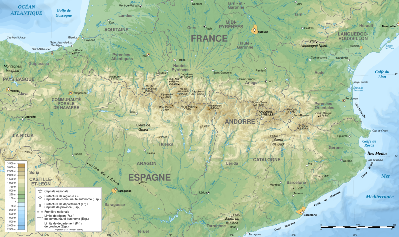
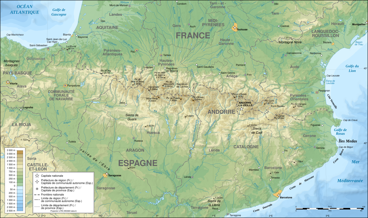
English: Topographic map in French of the Pyrenees mountains.
Note: The shaded relief is a raster image embedded in the SVG file. Français : Carte topographique des Pyrénées en francais.
Note : Le relief ombré est une image bitmap embarquée dans le fichier SVG. Português: Mapa topográfico (em Francês) dos Pirenéus.
Español: Mapa topográfico (en francés) de los Pirineos.
UTM projection; WGS84 datum; shaded relief (composite image of N-W, W and N lightning positions);
|
||
| SVG‑разработка | |||
| Күнэ-дьыла | May 2007 (modified September 2008) | ||
| Хантан ылыллыбыта |
Own work;
|
||
| Создатель | |||
| Маны оҥорор кыахтааххын (Бу билэни хос туттуу) |
|
||
| Georeferencing | If inappropriate please set warp_status = skip to hide. | ||
| Атын барыллар |
[]
|


Оценка
|

This image was selected as picture of the day on Wikimedia Commons for 1 August 2007. It was captioned as follows: English: Topographic map in French of the Pyrenees mountains. Other languages:
Čeština: Francouzská mapa pohoří Pyreneje Dansk: Topografisk kort over Pyrenæerne på fransk. English: Topographic map in French of the Pyrenees mountains. Français : Carte topographique des Pyrénées en français. Magyar: A Pireneusok térképe Nederlands: Franse Topografische kaart van de Pyreneeën Português: Um mapa topográfico em francês, da região dos Pireneus. Română: Hartă topografică a munților Pirinei, Franța. Suomi: Topografinen kartta Ranskasta, Pyreneiden vuorilta. Svenska: Topografisk karta över Pyrenéerna på franska. Русский: Топографическая карта Пиренеев. Українська: Топографічна карта Піренеїв 中文: 法语注释的比利牛斯山地形图 中文(繁體): 庇里牛斯山的法語地形圖 עברית : מפה טופוגרפית בצרפתית של הרי הפירינאים |
Лицензиялааһын
Мин, бу айымньыны бас билээччи, айымньыбын маннык лиссиэнсийэлэргэ сөп түбэһиннэрэн таһаарабын:

|
Бу дөкүмүөнү хатылыыр, тарҕатар уонна/эбэтэр уларытар GNU Free Documentation License лиссиэнсийэ 1.2 барыллын уонна онтон хойукку барылларын усулуобуйатынан көҥүллэнэр. Лиссиэнсийэни Көҥүл бырагырааммалар Пуондалара уларыйар салаалара, бастакы уонна бүтэһик тастарын тиэкиһэ суох бэчээттиир. Лисиэнсийэ маннык ааттаах салааҕа бэчээттэнэр GNU Free Documentation License. |
| Бу билэ Creative Commons Attribution-Share Alike 3.0 Unported усулуобуйатынан туһаныллар. | ||
| ||
| Лисиэнсийэлээһин бу тиэгэ бу билэҕэ GFDL лиссиэнсийэтин саҥардыллыытын быһыытынан эбиллибит. |
Бу билэ манна ааттаммыт лициензиялар усулуобуйаларынан туһаныллар: Creative Commons Attribution-Share Alike 2.5 Generic, 2.0 Generic уонна 1.0 Generic.
- Эн көҥүл:
- айымньыны тарҕатыаххын сөп – төгүллүөххүн, тарҕатыаххын уонна кимиэхэ эмэ биэриэххин сөп.
- туһанан атын айымньыны айыаххын сөп – уларытыаххын сөп
- Бу усулуобуйалары тутуһуохтааххын:
- атрибуция – Ааптары, лиссиэнсийэ тиэксигэр сигэни уонна ааптар уларыппытын дуу, суоҕун дуу ыйыахтааххын. Ханнык баҕарар ньыманнан ыйарыҥ бобуллубат, ол эрээри онтукаҥ лицензиат Эйигин бэйэҕин дуу, бу маны туһанаргын дуу өйүүрүн курдук санааны үөскэтиэ суохтаах.
- эмиэ оннук усулуобуйаҕа тарҕатыллар – Өскө бу айымньыны уларытар эбэтэр кини олоҕор атын айымньыны айар буоллаххына, ол саҥа айымньыны бу айымньы лиссиэнсийэтинэн эбэтэр онно сөп түбэһэр лиссиэнсийэннэн тарҕатыахтааххын.
Бу лиссиэнсийэлэртэн ханныгын баҕарар талыаххын сөп.
Билэ устуоруйата
Ыйын-күнүн/кэмин баттаа, оччотооҕуга баар буолбут.
| Күнэ-ыйа/Кэмэ | Ойуучаан | Кээмэйдэрэ | Кыттааччы | Хос быһаарыы | |
|---|---|---|---|---|---|
| билиҥҥи | 00:05, 14 Ахсынньы 2012 | | 3200 × 1900 (6,3 Мб) | Benh | uses Helvetica over Arial when available. |
| 15:49, 23 Балаҕан ыйын 2008 |  | 3200 × 1900 (6,3 Мб) | Sting | Using ETOPO1 data for bathymetry; new standard colors | |
| 00:25, 2 От ыйын 2007 |  | 3200 × 1900 (5,9 Мб) | Sting | + projection info in key ; + major cities areas ; some corrections in the rivers | |
| 20:30, 25 Бэс ыйын 2007 |  | 3200 × 1900 (5,88 Мб) | Sting | + key for borders | |
| 21:18, 31 Ыам ыйын 2007 |  | 3200 × 1900 (5,88 Мб) | Sting | Some corrections | |
| 18:23, 30 Ыам ыйын 2007 |  | 3200 × 1900 (5,88 Мб) | Sting | {{Information |Description=Topographic map in French of the Pyrenees mountains |Source=Own work ;<br/>Topographic map : [http://www2.jpl.nasa.gov/srtm NASA Shuttle Radar Topography Mission] (SRTM3 v.2) (public domain) edited with [http:// |
Билэни туттуу
Атын сирэйдэр бу билэни туһамматтар.
Билэни киэҥник туттуу
Бу билэ маннык биикилэргэ туттуллар:
- Манна af.wikipedia.org туттуу
- Манна an.wikipedia.org туттуу
- Манна ar.wikipedia.org туттуу
- Манна azb.wikipedia.org туттуу
- Манна ba.wikipedia.org туттуу
- Манна bs.wikipedia.org туттуу
- Манна ca.wikipedia.org туттуу
- Манна cs.wikipedia.org туттуу
- Манна en.wikipedia.org туттуу
- Манна eo.wikipedia.org туттуу
- Манна es.wikipedia.org туттуу
- Манна et.wikipedia.org туттуу
- Манна eu.wikipedia.org туттуу
- Манна fa.wikipedia.org туттуу
- Манна fi.wikipedia.org туттуу
- Манна fr.wikipedia.org туттуу
- Ariège (département)
- Aude (département)
- Andorre
- Sentier de grande randonnée 10
- Haute-Garonne
- Hautes-Pyrénées
- Pyrénées-Orientales
- Pyrénées
- Liste des communes des Hautes-Pyrénées
- Discussion:Liste des communes des Hautes-Pyrénées
- Pau
- Béarn
- Bayonne
- Tarbes
- Adour
- Ariège (rivière)
- Vals (Ariège)
- Catalogne
- Aragon (communauté autonome)
- Huesca
- Bizanos
- Pays basque
- Discussion:Béarn
- Discussion:Pau
- Val d'Aran
- Prades (Pyrénées-Orientales)
- Haute-Navarre
- Lugdunum Convenarum
- Lourdes
Билэ киэҥник туттуллуутун көрүү.