
Билэ:MarsPanoramaa.jpg

Билэ бэйэтэ (10 000 × 1248 пииксэл, билэ кээмэйэ: 11,49 Мб, MIME тиибэ: image/jpeg)
Быһаарыы
| Быһаарыыта |
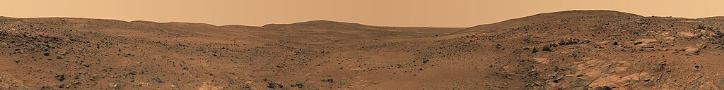
English: Descent from the Summit of 'Husband Hill'
In late November 2005 while descending "Husband Hill", NASA's Mars Exploration Rover Spirit took the most detailed panorama so far of the "Inner Basin", the rover's next target destination. Spirit acquired the 405 individual images that make up this 360-degree view of the surrounding terrain using five different filters on the panoramic camera. The rover took the images on Martian days, or sols, 672 to 677 (23 to 28 Nov. 2005). Français : Vue prise en descendant « Husband Hills », sur Mars. Panorama de 360° obtenu en assemblant 405 photos prises entre le 23 et le 28 novembre 2005 par l'astromobile Spirit de la NASA. Ce panorama est l'image la plus précise de l'« Inner Bassin ». On peut voir en explorant ce panorama en détail les pistes tracées par Spirit lors de son ascension de la colline. |
| Күнэ-дьыла | Nov. 23-28, 2005 |
| Хантан ылыллыбыта | NASA Jet Propulsion Laboratory[1] |
| Ааптар | NASA |
| Атын барыллар | Restored version of Image:MarsPanorama.jpg with cropping to remove blank patches and minor changes to address stitching flaws. |
| 360° | View in 360° panoramic viewer
|
|---|
|

Эта иллюстрация выбрана изображением дня для 12 января 2011 года. У неё следующее описание: English: Descent from the Summit of 'Husband Hill', panorama by Spirit Rover taken in 2005. Другие языки
Dansk: Nedkørsel fra toppen af "Husband Hill", en af Columbia-bakkerne i Gusevkrateret i Aeolis quadranglen (180-225° V, 0-30° S) på Mars. Optaget af den ubemandede rumsonde Spirit (en MER) fra 23.-28. november 2005 (Mars soltid, dag 672-677). English: Descent from the Summit of 'Husband Hill', panorama by Spirit Rover taken in 2005. Español: Descenso desde la cima de Husband Hill. Panorámica tomada por el Spirit a finales de noviembre de 2005 en Marte. Italiano: Discesa dalla sommità della collina Husband Hill su Marte ripresa dal rover Spirit durante la sua missione nel 2005. Magyar: Marsi tájkép a Husband Hill-ről nézve Nederlands: Afdaling van de kruin van de Husband Hill, een van de Columbia Hills in de Gusevkrater in het Aeolis-quadrangle (180-225° W, 0-30° Z) van Mars. Panorama gemaakt door het onbemande ruimtevaartuig Spirit (een MER) op 23 tot 28 november 2005 (sol/Martiaanse zonnedag 672 tot 677). Українська: Кругова панорама з вершини Пагорба Хазбенд на Марсі, світлини зроблені марсоходом «Спірит» 23 - 28 листопада 2005 р. 日本語: 火星のハズバンド・ヒル頂上からの下り坂。無人探査機スピリットによる撮影。 |
Лицензиялааһын
| Этот файл находится в общественном достоянии (англ. public domain), так как он был создан NASA (Национальным управлением по аэронавтике и исследованию космического пространства). Политика авторского права NASA гласит, что «Материал NASA не защищается авторским правом, если не указано иное». (См. Template:PD-USGov, страницу политики авторского права NASA или политику использования изображений JPL.) | ||
 |
Предупреждения:
|
Билэ устуоруйата
Ыйын-күнүн/кэмин баттаа, оччотооҕуга баар буолбут.
| Күнэ-ыйа/Кэмэ | Ойуучаан | Кээмэйдэрэ | Кыттааччы | Хос быһаарыы | |
|---|---|---|---|---|---|
| билиҥҥи | 06:40, 1 Кулун тутар 2008 | 10 000 × 1248 (11,49 Мб) | Durova | {{Information |Description= |Source= |Date= |Author= |Permission= |other_versions= }} | |
| 06:27, 1 Кулун тутар 2008 | 7000 × 874 (5,9 Мб) | Durova | {{Information |Description= |Source=self-made |Date= |Author= Durova |Permission= |other_versions= }} | ||
| 06:00, 1 Кулун тутар 2008 | 5500 × 686 (2,1 Мб) | Durova | {{Information |Description=Descent from the Summit of 'Husband Hill' In late November 2005 while descending "Husband Hill," NASA's Mars Exploration Rover Spirit took the most detailed panorama so far of the "Inner Basin," the rover's next target destinat |
Билэни туттуу
Бу билэни бу сирэй туһанар:
Билэни киэҥник туттуу
Бу билэ маннык биикилэргэ туттуллар:
- Манна ar.wikipedia.org туттуу
- Манна ba.wikipedia.org туттуу
- Манна be-tarask.wikipedia.org туттуу
- Манна be.wikipedia.org туттуу
- Манна bg.wikipedia.org туттуу
- Манна bn.wikipedia.org туттуу
- Манна crh.wikipedia.org туттуу
- Манна cv.wikipedia.org туттуу
- Манна da.wikipedia.org туттуу
- Манна en.wikipedia.org туттуу
- Mars rover
- Husband Hill
- User:Kotra
- Portal:Solar System/Selected picture
- User:Darkieboy236
- Wikipedia:WikiProject Media Restoration/Landmark images
- Wikipedia:Featured pictures thumbs/10
- Wikipedia:Featured picture candidates/March-2008
- Wikipedia:Featured picture candidates/Mars panorama
- Wikipedia:Wikipedia Signpost/2008-03-13/Features and admins
- User talk:Durova/Archive 53
- User:Orion11M87
- Wikipedia:Picture of the day/September 2008
- Template:POTD/2008-09-12
- Wikipedia:Wikipedia Signpost/2008-03-13/SPV
- User talk:Durova/Archive 62
- User:Durova/Featured credits at the Turkish language Wikipedia
- User:Darkieboy236/Sandbox
- User:Durova/Featured picture gallery/2008
- Portal:Outer space/Selected picture
- Portal:Outer space/Selected picture/28
- Wikipedia:Featured pictures/Space/Panorama
- Wikipedia:Wikipedia Signpost/Single/2008-03-13
- Манна en.wikiversity.org туттуу
- Манна es.wikipedia.org туттуу
- Манна fa.wikipedia.org туттуу
- Манна fr.wikipedia.org туттуу
- Манна hu.wikipedia.org туттуу
- Манна hy.wikipedia.org туттуу
Билэ киэҥник туттуллуутун көрүү.