
Билэ:150132main image feature 589 alaska.jpg

Билэ бэйэтэ (5600 × 4400 пииксэл, билэ кээмэйэ: 6,63 Мб, MIME тиибэ: image/jpeg)
Быһаарыы
| Быһаарыыта |
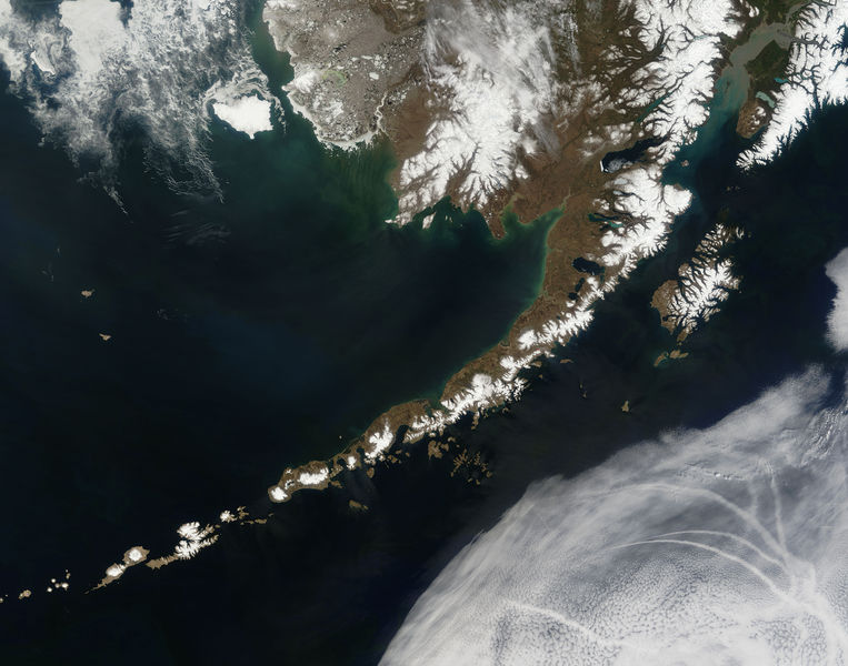
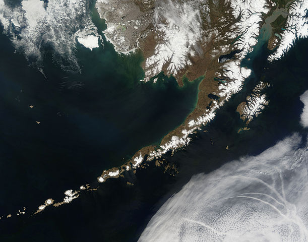
English: Satellite picture of the Aleutian Islands and the Alaska Peninsula, located in the south of the state of Alaska, United States.
Português: Imagem de satélite das Ilhas Aleutas e da Península do Alasca, localizadas no sul do estado do Alasca, Estados Unidos.
Original caption — The Aleutian Islands and the Alaskan peninsula are shown in this image acquired by the MODIS on the Terra satellite, on May 25th, 2006. The Aleutians are a chain of more than 300 small volcanic islands forming an island arc in the Northern Pacific Ocean. They extend about 1,200 miles westward from the Alaskan Peninsula. Nearly all of the islands are part of Alaska, but at the extreme western end of the archipelago are the small, geologically-related, but remote Komandorski Islands, which are considered part of Russia. The Aleutian Islands, with 57 volcanoes among them, are in the northern part of the Pacific Ring of Fire.
|
| Күнэ-дьыла | 25 Ыам ыйын 2006 |
| Хантан ылыллыбыта | NASA (Image galleries) |
| Ааптар | National Aeronautics and Space Administration (NASA) |
| Атын барыллар |
.jpg)
Оценка
Эта иллюстрация выбрана изображением дня для 2 сентября 2006 года. У неё следующее описание: Другие языки
Bân-lâm-gú: Ùi thài-khong koàⁿ Aleutian Kûn-tó kap Alaska Poàⁿ-tó Čeština: Aleutské ostrovy z oběžné dráhy. Cymraeg: Delwedd o'r gofod o'r Ynysoedd Aleutia a'r Gorynys Alaska. Magyar: Az Aleut-szigetek és az Alaszkai-félsziget az űrből nézve Polski: Aleuty i półwysep Alaska widziane z orbity ziemskiej Slovenščina: Aleutski otoki iz vesolja. |
Лицензиялааһын
| Этот файл находится в общественном достоянии (англ. public domain), так как он был создан NASA (Национальным управлением по аэронавтике и исследованию космического пространства). Политика авторского права NASA гласит, что «Материал NASA не защищается авторским правом, если не указано иное». (См. Template:PD-USGov, страницу политики авторского права NASA или политику использования изображений JPL.) | ||
 |
Предупреждения:
|
Билэ устуоруйата
Ыйын-күнүн/кэмин баттаа, оччотооҕуга баар буолбут.
| Күнэ-ыйа/Кэмэ | Ойуучаан | Кээмэйдэрэ | Кыттааччы | Хос быһаарыы | |
|---|---|---|---|---|---|
| билиҥҥи | 19:55, 14 От ыйын 2006 | | 5600 × 4400 (6,63 Мб) | Felipe Menegaz | {{Information| |Description= The Aleutian Islands and the Alaskan peninsula are shown in this image acquired by the MODIS on the Terra satellite, on May 25th, 2006. The Aleutians are a chain of more than 300 small volcanic islands forming an island arc in |
Билэни туттуу
Бу билэни бу сирэй туһанар:
Билэни киэҥник туттуу
Бу билэ маннык биикилэргэ туттуллар:
- Манна af.wikipedia.org туттуу
- Манна als.wikipedia.org туттуу
- Манна bn.wikipedia.org туттуу
- Манна ca.wikipedia.org туттуу
- Манна cs.wikipedia.org туттуу
- Манна de.wikipedia.org туттуу
- Манна eo.wikipedia.org туттуу
- Манна es.wikipedia.org туттуу
- Манна fr.wikipedia.org туттуу
- Манна gl.wikipedia.org туттуу
- Манна hu.wikipedia.org туттуу
- Манна ia.wikipedia.org туттуу
- Манна it.wikipedia.org туттуу
- Манна ja.wikipedia.org туттуу
- Манна ko.wikipedia.org туттуу
- Манна oc.wikipedia.org туттуу
- Манна os.wikipedia.org туттуу
- Манна pl.wikipedia.org туттуу
- Манна pl.wiktionary.org туттуу
- Манна pt.wikipedia.org туттуу
- Манна ro.wikipedia.org туттуу
- Манна ru.wikipedia.org туттуу
- Манна ru.wikinews.org туттуу
- Манна sk.wikipedia.org туттуу
- Манна sr.wikipedia.org туттуу
- Манна sv.wikipedia.org туттуу
- Манна tr.wikipedia.org туттуу